Throughout history, geography has shaped the destiny of nations. For the Netherlands, a country defined by its low-lying terrain and proximity to the sea, geography has dictated not only its economic development but also its military strategy. Surrounded by powerful neighbors and perpetually under the threat of invasion, the Dutch devised a unique approach to national defense: the deliberate use of water as a defensive weapon. This distinctive method manifested in a complex network of fortification lines that incorporated natural features, man-made infrastructure, and controlled flooding—collectively known as “waterlines.”
As Europe moved into the turbulent first half of the twentieth century, the need for robust national defenses became more urgent. The rise of Imperial Germany in the late nineteenth century, followed by the horrors of the First World War, deeply influenced Dutch military thinking. Although the Netherlands maintained a policy of strict neutrality, the devastating conflict that engulfed Europe underscored the vulnerability of even non-combatant nations. It was during this period of heightened strategic awareness that the Dutch modernized and expanded their existing fortification systems, investing heavily in what they hoped would be an impenetrable shield of inundation zones, fortresses, bunkers, and artillery positions.
Unlike the massive concrete and steel Maginot Line in France, the Dutch defenses were rooted in centuries of hydraulic engineering and land management. By flooding key areas of the countryside to create impassable wetlands, the Dutch hoped to restrict enemy mobility and channel attacks toward fortified strongholds. This system combined the ingenuity of water control—an essential aspect of Dutch life—with the lessons learned from traditional European fortification practices.

This essay explores the evolution and structure of Dutch fortification lines prior to World War II, focusing on their historical origins, design principles, and key components. From early efforts like the Old Dutch Waterline (Oude Hollandse Waterlinie) to the more sophisticated New Dutch Waterline (Nieuwe Hollandse Waterlinie) and the Grebbe Line (Grebbelinie), these defenses reflect a fusion of environmental adaptation, military innovation, and national identity. By examining the purpose, structure, and limitations of these lines, we gain insight into how the Netherlands sought to protect itself in an increasingly hostile world.
2. Historical Origins of Water-Based Defence (16th–18th Centuries)

The concept of using water as a defensive mechanism is deeply embedded in Dutch military history and national consciousness. Unlike many European countries that relied on mountainous terrain or massive stone fortresses, the Netherlands—situated largely below sea level—harnessed its most abundant and threatening natural resource: water. The strategic use of inundation, or the deliberate flooding of low-lying areas to create impassable barriers, has its roots in the early stages of Dutch state formation during the Eighty Years’ War (1568–1648) against Spanish rule.
2.1 The Birth of Waterlines: A Response to Existential Threat
The earliest example of a water-based defensive system can be found in the Frisian Waterline, developed during the late 16th century. The northern provinces, particularly Friesland and Groningen, faced repeated incursions from Spanish forces and sought to protect themselves by manipulating the landscape. The Dutch opened dykes, constructed temporary dams, and used existing river systems to flood strategic areas, thereby restricting enemy movement and creating natural chokepoints.
By the early 17th century, this rudimentary tactic evolved into more structured and systematic defences. The Old Dutch Waterline (Oude Hollandse Waterlinie) was first constructed in 1629 during the Eighty Years’ War and formalised shortly after the conclusion of the conflict. Stretching from the Zuiderzee (now IJsselmeer) southward to the river Biesbosch, this line of defence was intended to protect the economically and politically vital province of Holland—home to major cities such as Amsterdam, Rotterdam, and The Hague. The principle was simple: in the event of an invasion, key lowlands could be flooded to a depth of approximately 30 to 60 centimetres—shallow enough to prevent boats from sailing, but deep enough to bog down soldiers, horses, and wheeled artillery.
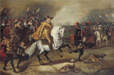
This concept reached its full strategic realisation during the Rampjaar (Disaster Year) of 1672, when the Dutch Republic was simultaneously attacked by France, England, and the bishoprics of Cologne and Münster. As French troops under Louis XIV advanced, the Dutch successfully deployed the waterline, halting the French at the city of Woerden. The inundation proved highly effective, buying time for a counter-offensive and reinforcing the value of water-based defence in Dutch military doctrine.
2.2 Technical and Tactical Features

The waterlines of the 17th and 18th centuries were not simple floodplains. They were intricate systems requiring precise control over terrain and hydraulics. Key components included:
-
Sluices and waterworks: These allowed for the controlled release of water from rivers and canals into designated flood zones. The proper functioning of these structures required years of planning and maintenance.
-
Dykes and dams: Often adapted from existing agricultural infrastructure, these elements helped contain and direct the flow of floodwaters.
-
Redoubts and forts (schansen): Positioned along dykes and key roads that traversed the waterline, these small fortresses provided protection for soldiers guarding the inundation zones and allowed for localised defence if the enemy attempted to cross at high points.
-
Observation towers and signalling systems: Used to monitor the progress of enemy troops and coordinate flooding operations in real time.
These systems demanded a high level of coordination between military engineers, local water boards (hoogheemraadschappen), and civilian authorities. This cooperation was a unique feature of Dutch defence, reflecting the broader societal reliance on collective water management.
2.3 Limitations and Evolution
While effective in deterring invasion, the early waterlines were not without limitations. Their functionality depended heavily on seasonal weather conditions. In dry summers or during periods of drought, it was difficult to raise water levels quickly. In winter, frozen water could actually aid an invading army by providing a flat, traversable surface. Moreover, the increasing range and power of artillery in the 18th century made fixed positions more vulnerable, necessitating greater dispersion and modernisation of defensive infrastructure.
Nonetheless, the waterlines demonstrated an innovative blending of military necessity and environmental adaptation. By the end of the 18th century, the Dutch were already contemplating upgrades to these early systems—an effort that would culminate in the extensive defensive reforms of the 19th century.

3. 19th-Century Consolidation under the Fortification Law (1874)
The dawn of the 19th century saw dramatic changes in both European geopolitics and military technology. The Napoleonic Wars (1803–1815) had underscored the vulnerability of small nations to the ambitions of continental empires. Although the Netherlands managed to restore its independence following the French occupation, it became increasingly clear that its old defences, based on 17th-century engineering and tactics, were no longer adequate in the face of modern warfare. The rapid advances in artillery power, logistics, and mobility demanded a reassessment of national defence strategy.
This reassessment came in the form of the Fortification Law of 1874 (Vestingwet), one of the most important pieces of Dutch military legislation in the modern era. Prompted in part by the shock of the Franco-Prussian War (1870–1871)—which demonstrated the devastating impact of modern military forces—the law provided a comprehensive legal and strategic framework for the reorganisation of the Netherlands’ national defences.
3.1 Strategic Doctrine and National Defence Philosophy
The underlying philosophy of the 1874 Fortification Law was based on a principle known as the "Fortress Holland" (Vesting Holland) concept. Rather than attempting to defend the entire national territory—an impractical objective for a small and relatively flat country—the Dutch military proposed to concentrate its efforts on protecting the political, economic, and administrative heartland: the western provinces of North Holland, South Holland, and Utrecht. This region contained the nation’s largest cities, key infrastructure, ports, and economic resources.
To defend this core area, the Dutch state would employ a belt of permanent fortifications and water-based defences, supported by inland flooding zones and reinforced positions. The logic of the plan was twofold: firstly, to use the country’s own geography to restrict enemy movement, and secondly, to create a delay long enough to allow for international diplomatic efforts—or a military alliance—to come to the Netherlands' aid.
This doctrine mirrored the nation’s long-standing policy of armed neutrality. While the Netherlands did not wish to become entangled in great power conflicts, it recognised the necessity of appearing capable of serious resistance in the event of invasion. The Fortification Law thus represented a compromise between geopolitical realism and technological modernisation.
3.2 Upgrading and Modernising the Waterlines
One of the most significant consequences of the 1874 law was the modernisation of the New Dutch Waterline (Nieuwe Hollandse Waterlinie). Originally conceptualised in the early 19th century and partly constructed during the Napoleonic period, the line stretched from Muiden, near Amsterdam, in the north to the Biesbosch in the south—a distance of over 85 kilometres. The intention was to update this critical line to suit modern warfare by strengthening fortifications, improving waterworks, and extending the line to include more effective fieldworks.

Among the key upgrades were:
-
Reconstruction of existing forts: Older bastioned forts were either replaced or heavily reinforced with concrete casemates, earthen ramparts, and armoured gun turrets.
-
Construction of new fortresses: Dozens of new forts, such as Fort Vechten, Fort Rijnauwen, and Fort bij Vijfhuizen, were built between the 1870s and the 1920s. These fortifications typically featured thick concrete walls, underground barracks, and artillery emplacements designed to withstand modern shellfire.
-
Expansion of sluice and canal systems: The hydraulic infrastructure was critically examined and redesigned where necessary to allow faster and more reliable flooding of strategic zones. This involved not only the creation of new sluices and pumping stations but also the protection of these systems from sabotage.
-
Integration with rail and road networks: The Dutch military adapted to modern logistics by ensuring that fortresses were accessible by rail, allowing for the rapid movement of troops and materiel in times of crisis.
3.3 Strategic Fortified Towns and Defensive Rings
The Fortification Law also led to the designation of several strategic fortified towns across the Netherlands. While “Fortress Holland” remained the centrepiece, smaller urban centres were fortified to act as strongholds or delay points in the event of a broader invasion. Among these were:
-
Naarden: An old star fort city updated for use as a regional command centre.
-
Gorinchem and Woudrichem: Located near key river junctions and incorporated into the southern end of the New Dutch Waterline.
-
Hellevoetsluis and Willemstad: Coastal fortresses tasked with protecting naval bases and estuarine access points.

Moreover, new defensive concepts were introduced, such as the Defence Line of Amsterdam (Stelling van Amsterdam)—a ring of 46 forts surrounding the capital, situated at distances of 10 to 15 miles from the city centre. This remarkable undertaking, which began construction in 1880 and continued into the early 20th century, demonstrated the continued commitment to layered, concentric defence zones based on water and fortifications.
3.4 Limitations of the Fortification Law
Despite its foresight, the 1874 Fortification Law was not without flaws. By the time many of the new defences were completed—often decades after initial planning—military technology had again moved forward. The emergence of air power, mechanised infantry, and long-range artillery rendered even concrete forts vulnerable to modern bombardment.
Furthermore, the emphasis on static fortifications, while logical in a geographic and political sense, began to appear outdated in the context of more mobile and mechanised military doctrines being adopted elsewhere in Europe. Critics within the Dutch military establishment argued that too much investment had been made in fixed positions and not enough in mobile field armies or anti-aircraft capabilities.
Nevertheless, the legacy of the Fortification Law was profound. It laid the institutional and physical foundation for Dutch defensive thinking well into the 20th century. The forts and waterlines it helped to create would serve—albeit briefly and under intense pressure—during the opening days of the Second World War.
4. Core Fortification Lines Leading to World War II
By the early 20th century, the Netherlands found itself in a precarious position. Despite its historic policy of neutrality, it was increasingly aware that technological developments in warfare—particularly the advent of aerial bombardment, mechanised divisions, and chemical weapons—posed new threats to its traditional defence structures. As the Second World War loomed, the Dutch military sought to reinforce and reconfigure its network of fortifications. This effort focused primarily on three major systems: the New Dutch Waterline, the Defence Line of Amsterdam, and the more modern Grebbe Line, each reflecting different eras of Dutch strategic thought and engineering prowess.
4.1 The New Dutch Waterline (Nieuwe Hollandse Waterlinie)
Building upon the foundations laid in the 19th century, the New Dutch Waterline remained the backbone of the country’s inland defence system in the lead-up to the Second World War. It stretched over 85 kilometres, running in a rough north-south orientation from Muiden, just east of Amsterdam, down to the Biesbosch wetlands near Gorinchem.
4.1.1 Strategic Purpose and Structure
The line’s primary purpose was to shield the economic heartland of the Netherlands—including Amsterdam, Utrecht, and Rotterdam—by forcing any invading army to cross vast, waterlogged zones, while simultaneously channelling their movement towards heavily fortified strongpoints.
The key features of the New Dutch Waterline included:
-
Controlled inundation fields: Areas of farmland and polder that could be intentionally flooded via a network of sluices, pumping stations, canals, and locks. These fields were maintained in a state that allowed rapid flooding in the event of war.
-
Forts and batteries: A total of 45 large forts and hundreds of smaller redoubts were positioned along dykes, roads, and railway lines to defend any dry passages across the waterline. Notable examples include Fort bij Vechten, Fort bij Rijnauwen, and Fort Honswijk.
-
Camouflaged infrastructure: By the 1930s, many fortifications were reinforced or partially concealed, with machine gun nests, concrete bunkers, and command posts hidden under natural cover or blended into the landscape.
Despite these improvements, by the 1930s the line was no longer considered modern. The Dutch General Staff recognised that the rise of motorised warfare and the Luftwaffe’s bombing capabilities could bypass or undermine traditional water-based defences.
4.2 The Defence Line of Amsterdam (Stelling van Amsterdam)
Encircling the capital city in a radius of approximately 15 to 20 kilometres, the Defence Line of Amsterdam was conceived as a final line of retreat and defence. Designated a UNESCO World Heritage Site in the 21st century, it was among the most ambitious defensive undertakings in Dutch history.

4.2.1 Design and Functionality
Constructed between 1880 and 1920, the line comprised 46 forts, numerous sluices, pumping stations, and over 135 kilometres of water-based defences. Like the New Dutch Waterline, it relied on controlled flooding, but it was also designed to integrate with mobile field armies in the event of a siege.
Key characteristics included:
-
Circular design: Rather than a linear barrier, the Defence Line formed a near-complete ring, allowing for defence in all directions. The forts were situated at intervals to provide overlapping fields of fire.
-
Concrete fortresses: While early designs featured brick and earth ramparts, later forts were constructed using reinforced concrete, which was resistant to high-explosive artillery shells.
-
Urban integration: Planners ensured that the defences included logistical and transport routes necessary for military operations and civilian evacuation.
4.2.2 Limitations in the Interwar Period
Despite its scale and sophistication, by the 1930s the Stelling van Amsterdam was considered strategically obsolete. It had not been modernised to cope with aerial assault or armoured divisions, and the water defences were susceptible to freezing during harsh winters. Moreover, it was never fully mobilised or tested in battle.
4.3 The Grebbe Line (Grebbelinie)

With the growing threat posed by Nazi Germany, the Dutch military acknowledged that traditional waterlines might not be sufficient to stop a modern, mechanised invasion. As a result, attention turned to creating a forward defensive line further east: the Grebbe Line.

4.3.1 Location and Strategic Purpose

The Grebbe Line ran from the Ijsselmeer in the north to the Grebbeberg near Rhenen, following the eastern edge of the Utrechtse Heuvelrug. It was designed to delay or repel a surprise attack from the German border, thereby providing time for the western defences to be fully prepared and the waterlines to be inundated.
Unlike the older lines, the Grebbe Line relied less on flooding and more on modern fortifications:
-
Concrete bunkers: Constructed in the 1930s, these housed machine guns, mortars, and light artillery.
-
Anti-tank obstacles: Steel barriers (so-called “dragon’s teeth”) and minefields were laid out to hinder enemy armour.
-
Infantry trenches and casemates: Soldiers were stationed in extensive trench systems supported by fortified casemates, many of which were camouflaged.

4.3.2 The Battle of the Grebbe Line, May 1940
The Grebbe Line was the only major Dutch defence line to see significant combat during the German invasion of May 1940. Over the course of several days, German forces launched a sustained attack on the Grebbeberg, using superior artillery, air support, and infantry tactics.

While Dutch defenders fought valiantly, the line was eventually breached on 13 May 1940. The fall of the Grebbe Line forced a general retreat toward the New Dutch Waterline, but with the Luftwaffe already bombing key cities—including Rotterdam—the Netherlands surrendered shortly thereafter, on 15 May.
4.4 Other Defensive Lines and Coastal Fortifications
In addition to the major inland waterlines, the Netherlands constructed and maintained coastal defences to protect vital estuaries and harbours:
-
Fortress Hook of Holland (Hoek van Holland): Protected access to the Rotterdam port and served as a naval base.
-
Zeeland coastal batteries: Forts and artillery positions along the Scheldt estuary were intended to prevent landings and control maritime traffic.
However, these too were generally outdated by 1940 and played only limited roles in resisting the German blitzkrieg.
.jpg)
The combined system of fortification lines—rooted in centuries of Dutch hydraulic ingenuity and reinforced by 19th- and early 20th-century engineering—offered a comprehensive, if ultimately insufficient, response to the challenges of modern warfare. In the following section, we will examine the engineering principles, military doctrines, and operational elements that defined these defensive structures in greater detail.
5. Key Elements and Operational Principles of Dutch Fortifications
Dutch fortifications constructed prior to the Second World War were rooted in a unique blend of hydraulic engineering, traditional military architecture, and evolving defensive doctrine. These systems were not isolated structures but part of a broader landscape-oriented strategy which harmonised with the country’s geography, climate, and technical capabilities. Understanding the operational principles and physical components of these fortifications sheds light on their intended function and the ingenuity behind their design.
5.1 Water as a Weapon: Inundation Strategy
At the heart of the Dutch defensive approach was inundation, the controlled flooding of low-lying land to create physical and psychological barriers. This technique served not only to impede troop and vehicle movement, but also to disrupt enemy supply lines, morale, and strategic calculations.

Key aspects included:
-
Depth of floodwaters: The ideal depth ranged from 30 to 60 centimetres—too shallow for boats but too deep for infantry or cavalry to advance effectively. In such conditions, tanks and artillery pieces would become bogged down.
-
Speed and control: The efficiency of inundation relied on the rapid manipulation of sluices, locks, pumping stations, and culverts. Engineers were trained to respond quickly to any signal of mobilisation, often needing only 48–72 hours to flood key zones.
-
Seasonal and climatic challenges: The system was highly dependent on rainfall, river levels, and temperature. Prolonged droughts could delay inundation, while harsh winters introduced the risk of frozen water, which could facilitate enemy movement across what were meant to be barriers.
Because of this vulnerability, the Dutch designed fortification lines to include alternative dry defences, such as fieldworks and strongpoints, in case inundation proved unfeasible or ineffective.
5.2 Forts, Casemates, and Strongpoints
Forts were the cornerstone of the physical fortification system. While their form and material changed over time, their purpose remained constant: to protect key access points, such as roads, dykes, canals, and bridges.
Types of fortifications included:
-
Polygonal forts: These 19th-century structures were typically surrounded by moats, with bastioned corners and multi-directional fields of fire. Examples include Fort bij Vechten and Fort Pannerden.
-
Concrete casemates and bunkers: Introduced in the early 20th century to resist explosive shells, these were often camouflaged or partially buried. They housed machine guns, anti-tank weapons, and observation posts.
-
Command centres: Heavily reinforced buildings used for coordination and communication, often equipped with telephone lines and signalling equipment.
Each fort or bunker functioned as part of a broader mutually supporting network, capable of delivering overlapping fire and maintaining continuity even if one position was lost.
5.3 Defensive Zones and Tactical Layout

Dutch defence lines were conceived as multi-layered systems, not single obstacles. Each line was composed of several functional zones:
-
Observation and warning zone: Outposts and elevated towers provided early warning of enemy activity, often supported by local civilian watch units.
-
Inundation zone: Designed to be flooded within hours, these areas formed the main obstacle against mechanised or mounted units.
-
Support zone: This included artillery emplacements, logistic depots, and access roads, protected by infantry trenches and bunkers.
-
Rear zone: Command facilities, field hospitals, and transportation hubs were placed here, safeguarded against long-range artillery and air attack.

This layered structure allowed for tactical depth, meaning defenders could fall back in stages without losing coherence or control of the battlefield.
5.4 Communications and Mobility
Effective communication and rapid troop movement were crucial for maintaining the integrity of defensive operations.
-
Railway integration: Many forts were linked by branch railway lines, allowing reinforcements and supplies to be moved quickly. Rolling stock could be used to evacuate civilians, transport artillery, or resupply isolated garrisons.
-
Military roads: Specially built roads were kept in reserve for military use during mobilisation. These were often built higher than flood zones to remain passable during inundation.
-
Signal systems: Visual and electrical signalling, including telegraph lines, signal lamps, and later telephone networks, facilitated coordination between forts.
Although effective for the late 19th century, these systems were increasingly vulnerable to air raids and signal interception by the 1930s.
5.5 Civil and Military Coordination
A defining feature of the Dutch defensive system was its reliance on cooperation between military planners, civil engineers, and local water authorities (hoogheemraadschappen). Unlike most European fortification strategies, Dutch waterlines required integration with peacetime water management systems.
Key elements of this collaboration included:
-
Joint planning committees: These oversaw the construction, maintenance, and potential operation of inundation systems.
-
Civil engineering input: Civilian water boards played an essential role in maintaining sluices, dykes, and pumping stations.
-
Requisition laws: The Dutch government retained the right to commandeer private land, buildings, and water infrastructure in the event of mobilisation.
This civil-military synergy enabled an otherwise small country to maximise its natural and infrastructural resources, though it also introduced complexities in terms of command, logistics, and decision-making under crisis conditions.
5.6 Limitations and Strategic Obsolescence
Despite the ingenuity and technical sophistication of these fortifications, they were not immune to the strategic shifts of the early 20th century:
-
Air power: The Luftwaffe’s bombing campaigns in 1940 quickly demonstrated that fixed defences without sufficient air cover were highly vulnerable.
-
Mechanised warfare: Blitzkrieg tactics employed by the Wehrmacht exposed the weaknesses of linear and passive defensive systems, which lacked flexibility and manoeuvrability.
-
Psychological impact: The destruction of Rotterdam by aerial bombing had a demoralising effect on both civilians and command structures, hastening the national surrender even before many inland defences could be fully mobilised.
In essence, while the operational elements of Dutch fortifications were admirably suited to the conditions and technologies of the 19th century, they were outpaced by the rapid evolution of modern warfare in the 1930s.
6. Legacy and Historical Assessment
The story of Dutch fortification lines before the Second World War is one of remarkable ingenuity, resilience, and adaptation to a challenging geographic and strategic reality. While these defences ultimately failed to prevent German occupation in 1940, their legacy remains profound—both in military history and in the collective memory of the Netherlands.
6.1 Performance During the German Invasion (May 1940)
The German invasion of the Netherlands, launched on 10 May 1940, was swift, overwhelming, and methodically planned. Despite the Dutch government's policy of neutrality, the Third Reich viewed the Netherlands as a vital corridor to northern France and a buffer against British intervention. The Wehrmacht deployed a combination of paratroopers, mechanised infantry, and aerial bombardment—hallmarks of Blitzkrieg warfare that exposed the inherent weaknesses of traditional fortifications.
6.1.1 Rapid Bypass of Key Lines
The historic New Dutch Waterline and the Defence Line of Amsterdam, while technically intact, were largely bypassed or rendered redundant before full inundation could be achieved. German forces circumvented the waterlines by capturing key bridges, seizing airfields (such as Waalhaven near Rotterdam), and conducting airborne assaults behind Dutch lines. In some areas, weather and administrative delays meant that inundation zones were not fully operational by the time German units arrived.

6.1.2 The Grebbe Line and Tactical Resistance
The Grebbe Line, located further east and more modernised than the older lines, mounted the most determined resistance. For several days, Dutch forces held back German advances at the Grebbeberg, inflicting and sustaining heavy casualties. Nevertheless, with the fall of adjacent positions and the growing threat of encirclement, the line was eventually breached. The Dutch retreat into the heart of the country proved untenable, especially following the aerial bombardment of Rotterdam on 14 May, which killed hundreds and flattened the city centre.

Faced with the destruction of more cities and a collapsing defence network, the Dutch government surrendered on 15 May 1940. The southern province of Zeeland held out slightly longer, supported by French forces, but it too fell shortly thereafter.
6.2 Strategic and Doctrinal Shortcomings

Though steeped in tradition and engineering expertise, the Dutch fortification strategy was ultimately a product of the previous century, and it suffered from a number of critical flaws in the face of modern warfare:
-
Overreliance on passive defences: The waterlines depended on flooding and static positions, but lacked the mobile forces needed to respond dynamically to German advances.
-
Outdated air strategy: Little had been done to modernise Dutch air defences. As a result, fortresses and cities alike were vulnerable to sustained aerial attack.
-
Communication breakdowns: The decentralised nature of the water management system made coordinated mobilisation slow and prone to logistical delays.
-
Technological gap: The Dutch army was poorly equipped compared to the German forces. Artillery, armour, and air support were all inferior both in quality and quantity.
These issues were not due to negligence but rather to constrained defence budgets, political ambivalence about military investment, and a general underestimation of the speed and brutality of modern warfare.

The Dutch fortification lines constructed before the Second World War stand as enduring reminders of a nation that used its most abundant natural element—water—as its shield. Though ultimately overtaken by technological change and geopolitical reality, they remain monuments to a distinctively Dutch synthesis of engineering, geography, and national identity.
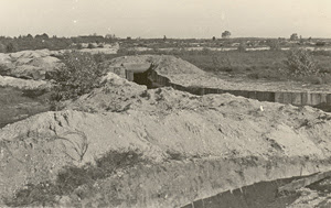
7. Analysis of the Bunkers Used
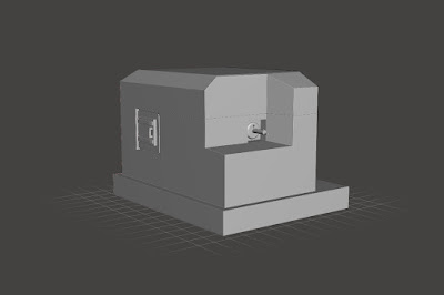
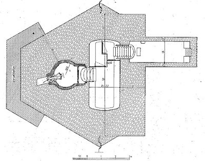
The bunkers constructed as part of the Dutch fortification system prior to the Second World War represent a significant evolution in military architecture, shaped by both necessity and resourcefulness. Typically built from reinforced concrete, these structures were designed to house machine guns, light artillery, observation equipment, and infantry units. Many were semi-subterranean, with only firing slits and ventilation chimneys visible above ground, often camouflaged with earth, vegetation, or wooden facades to blend into the surrounding landscape. Their placement was highly strategic—guarding roads, bridges, sluices, and the dry crossings of inundation zones. The bunkers came in several standardised models, known as kazematten, with variations in thickness and armament depending on their function and location. Despite their robust construction, however, they had notable weaknesses: ventilation was poor, living conditions for garrisons were harsh, and many lacked the means to withstand sustained aerial or artillery bombardment by modern German forces. In May 1940, several bunkers—especially along the Grebbe Line—were fiercely defended and proved tactically useful in delaying German advances. Nevertheless, their effectiveness was limited by poor coordination, lack of mobile support, and an overall defensive doctrine that had not fully adapted to rapid mechanised warfare. Even so, the bunkers remain a poignant symbol of Dutch resistance and technical competence in a time of mounting geopolitical threat.
B-Kazemat

The B-Kazemat was a key component of the Dutch pre-war defensive infrastructure, designed primarily to accommodate a machine gun and a crew in a semi-permanent fortification. Constructed largely of reinforced concrete, these bunkers were compact but robust, often built into natural embankments or behind dykes to reduce their visibility to enemy forces. The shape was typically angular, designed to deflect small arms fire and shrapnel effectively.

Internally, the B-Kazemat offered basic shelter with firing apertures carefully positioned to provide a wide arc of fire over designated killing zones. Space was strictly functional, allowing for the weapon, limited supplies, and a small number of personnel. Though lacking in comfort, they were efficient field fortifications meant to bolster the Dutch lines, particularly in conjunction with other structures like tank obstacles or water barriers.
While not formidable by modern standards, the B-Kazemat was a practical solution within the limits of Dutch military budgets and strategic doctrine of the 1930s. Their presence often served more as a psychological deterrent than an impenetrable defence, but in the early stages of the German invasion in 1940, many held out briefly against superior forces before being overrun or bypassed.

G-Kazemat

The G-Kazemat represented one of the most advanced Dutch defensive structures built before the Second World War. Designed for a heavier calibre of firepower than smaller bunkers, it could house field guns or heavier machine guns depending on tactical need. The bunkers were larger in footprint than B-Kazemats, with more intricate interior arrangements and significantly thicker concrete walls, often exceeding one metre in thickness.

These bunkers were usually situated at critical defensive positions—road crossings, dykes, river fords—where they could provide direct or flanking fire on advancing enemy units. The gun ports were engineered to allow both frontal and enfilading fire, making these bunkers crucial to interlocking fields of defence. In many cases, a G-Kazemat would be complemented by smaller bunkers to protect its flanks or by obstacles like anti-tank ditches.

Internally, G-Kazemats were divided into multiple compartments including a main gun chamber, a crew shelter, and storage areas for ammunition and supplies. Ventilation was rudimentary but sufficient for limited operations under combat conditions. Access points were heavily reinforced and sometimes protected by steel doors or blast baffles to limit the effect of explosive charges.
One of the defining features of the G-Kazemat was its adaptability. Depending on regional requirements, it could be customised for use with anti-tank guns, anti-aircraft equipment, or standard infantry weaponry. The Dutch military doctrine at the time prioritised flexibility, and the G-Kazemat was a physical manifestation of this approach.
Despite their engineering merits, G-Kazemats were undermined by the rapid pace of warfare in May 1940. The German blitzkrieg tactics rendered static fortifications vulnerable, particularly when air power and mechanised units could circumvent or overwhelm fixed defences. Nevertheless, in areas like the Grebbe Line, G-Kazemats were the scenes of fierce and valiant resistance.

Today, many G-Kazemats still stand as silent sentinels, reminders of the Netherlands' earnest but ultimately overwhelmed efforts to defend its sovereignty during one of the darkest chapters of European history. Their enduring presence speaks to the durability of Dutch engineering and the sacrifice of those who manned them.

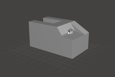
Groepshelter-Type-P (Piramide)

The Groepshelter-Type-P, colloquially referred to as the "Piramide" due to its pyramidal roof structure, was designed to offer emergency shelter for infantry units under bombardment. Constructed with sloped concrete walls to deflect artillery fire, it could accommodate approximately 10 to 12 soldiers in seated or crouched positions.

Though not equipped for sustained combat, the shelter allowed troops to withstand short-duration shelling before returning to the field. Its primary value lay in preserving manpower during aerial or artillery attacks, particularly in forward positions where permanent housing was impractical. The pyramid form was not only distinctive but structurally efficient in distributing explosive force.
.jpg)
Kanon Kazemat 6 Veld

The Kanon Kazemat 6 Veld was a specialised gun bunker designed to house the 6 Veld, a standard Dutch field gun of the early 20th century. Integrated into defensive lines, these casemates provided covered firing positions for artillery crews, allowing them to engage enemy armour and infantry from a protected emplacement. The gun embrasure was reinforced to handle the weapon's recoil, while the surrounding concrete offered limited protection from return fire.
River Kazemat Type A

River Kazemat Type A was tailored specifically for river defence, positioned strategically along key waterways. Typically situated behind river dykes or embankments, these casemates offered protected firing positions for machine guns or small anti-tank guns. Their role was to delay or prevent enemy river crossings, particularly in areas where bridges or fords presented tactical vulnerabilities.
River Kazemat Type B

River Kazemat Type B was a more developed evolution of the Type A, built to withstand heavier fire and offer broader fields of engagement along the Netherlands’ intricate river systems. These bunkers were placed where rivers could be exploited by an attacking force for rapid advancement and thus required a more permanent and heavily armed deterrent.


The structure included reinforced concrete walls, sometimes up to 1.5 metres thick, and firing slits optimised for both machine guns and anti-tank rifles. In many cases, they also incorporated angled approaches or anti-blast entrances, designed to limit the effect of enemy grenades or demolition charges. Their placement ensured crossfire across riverbanks, creating choke points to repel bridging attempts.

Inside, River Kazemat Type B bunkers were spartan but functional, often accommodating a crew of four to six. Provisions were made for extended occupancy during combat situations, including simple benches, ventilation shafts, and small stores of food and ammunition. The crew's primary task was to deliver sustained fire on crossing points while coordinating with nearby infantry and artillery units.

Though immobile, their effectiveness depended largely on the integration with mobile field forces and the natural obstacles presented by the Dutch landscape. In areas where rivers were vital for both transport and defence, these casemates played a crucial role in shaping German tactical movements during the early days of the invasion.

River Kazemat Type C

The River Kazemat Type C, unique to the Zwolle region, represented a regional adaptation to local topography. These bunkers were embedded deeply into the riverbank, offering a low profile and a concealed firing position. Their design capitalised on natural elevation changes to maximise visibility across the river while minimising exposure.

They typically housed a light machine gun or rifle crew and were manned by small detachments. Though not numerous, their positioning and integration with regional defences added a layer of depth to the Dutch defensive network in Overijssel, particularly in delaying enemy attempts to exploit the IJssel river line.
S-3 Kazemat

The S-3 Kazemat was one of the principal machine gun bunkers used in the Dutch pre-war defensive lines. Designed to accommodate a single light or heavy machine gun team, the S-3 featured thick reinforced concrete walls and a compact, angular form optimised for stealth and ballistic protection. It was most often found along canals, roads, and railway lines.

The S-3 was usually integrated into linear defensive systems, with each bunker covering a fixed field of fire that overlapped with neighbouring structures. This configuration allowed for concentrated fire zones and enhanced resistance to frontal attacks. Visibility was limited to the gun slit, which was precisely aligned with the expected direction of enemy movement.

Despite their sturdy design, S-3 bunkers lacked facilities for prolonged engagement. They offered minimal comfort, as they were meant for short-term defensive action during an immediate threat. Crew members often rotated in and out from nearby shelters or field positions. Ventilation and internal lighting were minimal, relying on natural airflow and daylight through the embrasure.
During the May 1940 campaign, many S-3 bunkers were engaged in the opening hours of battle, particularly in the Grebbe Line. While unable to withstand heavy artillery or coordinated assaults, they nonetheless played a role in slowing down enemy advances and buying time for Dutch mobilisation efforts.
S-3k Kazemat
The S-3k Kazemat was a variant of the standard S-3, modified to accommodate a heavy machine gun (HMG) and its crew. The gun port was slightly enlarged and reinforced to support the added recoil and field of fire required for heavier weapons. Internally, additional space was allotted for ammunition storage and a gun mount.

This type was particularly effective in fixed defensive roles where a high rate of sustained fire was needed to cover wide approaches. Though still limited in mobility and protection against heavy ordnance, the S-3k played a vital role in interlocking machine gun positions across key defensive zones.
S-4 Kazemat
The S-4 Kazemat was designed for use with a light machine gun, offering a minimalist and compact concrete position ideal for defending narrow corridors such as canal bridges or minor roadways. It was one of the smallest fortifications in the Dutch inventory but allowed for fast construction and strategic placement.

Crewed typically by two men, it focused on delivering enfilading fire across a restricted arc. While offering little protection from large-scale bombardment, the S-4 was effective in delaying enemy patrols and securing static lines against surprise incursions. Its simplicity was its greatest strength.

And thus, we have finished our tour of the stout and stoic stars of the show: the Dutch fortifications of 1940—bunkers so solid, even the most impolite artillery shells bounced off with an apologetic ping. These marvels of reinforced concrete and Calvinist resolve are now gloriously represented in miniature form, so finely detailed that one feels compelled to salute before assembling them. A tabletop without them is like a pancake without stroop—functional, perhaps, but utterly lacking in Dutch flavour.
What makes this release so scrumptiously exciting is the sheer character packed into every pillbox and casemate. We’re talking bunkers that look like they’ve read De Telegraaf, resisted tyranny, and still had time to mow the lawn. From the Grebbe Line to the Waterlinie, these fortifications are perfect for adding some unshakeable Dutch defiance to your wargaming table—because nothing says “You shall not pass” like a low-slung concrete cube bristling with intent.
Why should you care, you ask, as you sip your lukewarm tea and eye your cluttered terrain drawer? Because these models aren’t just terrain—they’re storytelling. They whisper tales of last stands, brave resistance, and a nation holding the line against all odds (preferably while cycling briskly away from the enemy). Your tabletop deserves more than generic ruins and ambiguous rubble. It deserves bunkers with a backstory and trenchlines with a touch of gezelligheid.
So hop to it, good gamer! Don’t be the sorry soul left peering wistfully through the shop window while others gleefully deploy their Dutch defences. March, scramble, or peddle furiously if you must—but get these fortifications into your collection before they’re gone. The Netherlands stood firm in 1940—now it’s your turn to bring that quiet courage and excellent concrete craftsmanship to your battles. Onward, to the checkout—there’s a casemate with your name on it!
... and bring your bayonet!
No comments:
Post a Comment